July 25, 2026, Saturday

Nepal India Border Dispute, Who’s Right?
Nepal and India have always been great neighbors. If any two countries exist in the past that have the closest relation, then it’s Nepal and India for sure. Considering its culture, tradition, language, the major religion of the nation, as well as for trade, both countries share a common intersection. These two nations can be counted among those countries whose citizens don’t need any kind of visas and passport, to go from one nation to another to stay and even work. Meanwhile, we can also say that they share an open border of 1690 KM with each other which is running between Nepal and India since 1816 after the Treaty of Sugauli conducted between the East India Company and the Nepalese Government.
But this friendship of kith and kin seems to deem in recent days when the political map of India and Nepal intersects certain regions in Limpiyadhura, Lipulekh, and Kalapani. When the Indian Government led by PM Modi published its political map on October 31, 2019, Nepal denied the political map because Nepal claims that the published map includes the territory supposed to be of Nepal. This is when the reason for the border dispute in recent days came forward. As the consequences of this newly published map, there was a huge protest conducted in Kathmandu by the civilian. Later on 8th May 2020, when both the countries were in Covid-19 lockdown, India inaugurated the Kailash-Mansarovar track without prior notice or negotiation with the government of Nepal. And the Nepalese government raised this issue farther by publishing the new political map of Nepal including the Limpiyadhura, Lipulekh pass, and Kalapani region based on the historical shreds of evidence, artifacts, and documents. This step of the government is highly criticized by the Indian Media. And the Indian media is claiming that this step of the Nepalese government is highly pressurized by the Chinese government. The tension between these two countries in recent days is building up rapidly. Not only the government but the civilians also have started passing hate comments across the border. And I think this issue should be resolved very soon before it’s too late for the remarkable historical friendship between these two nations. Before coming into the main topic: Who’s right?, I would like to highlight some of the historical data and events that exist between these neighboring nations. For this, I have to take you back to 1816.
1816, The Treaty of Sugauli
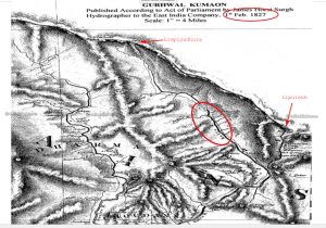
Before 1816, Nepal was a big nation. It was spread from the Kangada fort in the West till the Testa river in the east and also includes some regions in the south which lies in modern-day India. This bigger Nepal is denoted by Greater Nepal. As the consequences of the Anglo-Nepalese war fought between 1814-1816, Sugauli Sandhi or Treaty of Sugauli was held. This treaty was held between the British Government as East India Company and Raj Guru Gajaraj Mishra and Chandra Shekhar Upadhaya for the Nepalese Government. In article 5 of this Sugauli treaty, the Western border of Nepal is denoted by the Mahakali river also known as the Kali river. The article reads “The Rajah of Nepal renounces for himself, his heirs, and successors all claim to or connection with the countries lying to the west of the river Kali and engages never to have any concern with those countries or inhabitants thereof.” After the Sugauli Treaty the map of Nepal seems to be like this, including Limpiyadhura as its westernmost border.
Shifting The Map of Nepal In the 1860s
Later in the 1860s, the map was published again by the Indian side (the then East India Company), which unfairly shifted the border towards Kalapani showing the origination of the Kali river as Kalapani but not Limpiyadhura. This map shows Lipulekh is a trijunction area under Nepal. There was no treaty done where both sides agree on this statement. During this time Nepal has a Rana Regime, an autocratic government. There is no response or very little objection from the Nepal side, probably because of the weaker economy and unstable government. After that, Nepal and India both had been following the unofficial border until 1962 (The Sino-Indian War).
After The Sino-Indian War
To highlight you about Sino-Indian War, it was the war fought between India and China in 1962 due to the disputed Himalayan border. At that time Nepal was under monarchy led by King Mahendra. Since, Nepal and India then was closely related and had a very good friendship, India asked King Mahendra to settle a temporary camp for the Indian army in Kalapani for the war which King Mahendra had no reason to deny for. They chose to build a camp in Kalapani because strategically it was better since it was in a higher place. And the Indian army could easily inspect the Chinese movement.Later after the war, there were several requests by the Nepalese Government to back out the Indian Army camp from the Kalapani region. But India forcefully stayed there and dismissed the request because Kalapani was strategically important for the protection of India. After that incident, Nepal had to go various internal governmental crises as well as a change in the system of government to panchayat so it couldn’t exert more pressure on the Indian Government. Later on, the Indian Government published the Kalapani and Lipulekh region as a disputed region. Nepal had no way to object that because of low economic conditions as well as a lack of skilled manpower to draw its map. And here is a fact for you, Nepal was able to publish its map only in 1975. Before that Nepal used to draw maps with the reference map of India and China.
After Democracy
Democracy came into Nepal very late in 1990. After democracy came into Nepal, people have a lot of freedom to raise voice and look at the treaties and agreements previously done. After this the claim for their disputed border became more frequent. In 2015, when India and China signed a contract for India-China Treaty for trade and track for Kailash Mansarovar Yatra which passes from tri-junction Lipulekh pass, Nepal was not involved there. Due to this, Nepal protests this act between China and India. China responded to that protest and cleared its position but India has been ignorant about this protest. There was no response from the side of India. Later on October 31st, 2019, when India published its new political map, it forcefully included the Kalapani region which was declared as a disputed region before. For this map, there was a huge protest done in Kathmandu by the civilian. Also the Nepalese government, sent a letter of disapproval calling for diplomatic negotiation, but again India didn’t respond. According to Deputy Prime Minister and Defense Minister of Nepal, Mr. Ishwor Pokhrel, the Nepalese government sent three diplomatic notes calling for the meeting but none of them were responded. The blockade that India imposed over Nepal in 2015 when Nepal drafted its first democratic constitution, was already enough to hate the Indian government and this ignorant act of the Indian Government added more hatred towards India among the Nepalese people. Also the friendship of India and Nepal was already a matter of question.Later this year in 2020, when Nepal again asked for the diplomatic negotiation with India, the Indian government responded to have a meeting only after COVID is over. But few days after this statement, on 08 May, 2020, the defense minister of India, Rajnath Singh, inaugurated the Kailash-Mansarovar track from the Kalapani region, which bought huge protest in Nepal among the civilian and government in the ruling party as well as in opposition party. Nepalese government showed the disapproval regarding this inaugurated track but India responded that the track passes through the territory of India. Soon after this ignorant behavior of India, compelled Nepal to publish its new political map including Limpiyadhura, Lipulekh, and Kalapani, stating that, this would be a base to negotiate on. This act of Nepalese government could not be ignored in India and there was a dispute occurred. Indian media as well as Army Chief came forward to state that this step of Nepal is highly influenced by the Chinese Government. Whereas Nepalese officials object that statement and claim that, this was only based on the historical and documented proofs and evidence they possess, and not by the influences from the third party.This is the history between Nepal and India border dispute. Who do you think is right? Please write in the comment section down below.
My Personal Opinion
If I have to decide on who’s right, I would say both and If I have to pick the wrong one, I would pick them both again. Say How?Listen, when Nepal published its new political map, it included the region of Limpiyadhura taking the Sugauli treaty of 1816 as the reference. But when the British India published a new map in the 1860s, stating Kalipani as the source of the Kali river, there was no objection from the Nepalese side. Even the Nepalese government drew its map later, taking reference with British India Map published in the 1860s, which shows acceptance of the map, of a kind. But in my personal opinion, Nepal rightfully belongs to the area of Kalapani and Lipulekh, which India forcefully took it away. It’s because, during the Sino-India war in 1962, India asked King Mahendra, the then king of Nepal to build a camp in Kalapani for the Indian army because of its strategic importance. But when the war ended, King Mahendra asked them to leave the region, but India didn’t back out their camp. The unstable government of Nepal and the stronger military power of India became the reason to not leave the camp. Also, India took advantage of a very rural area of Nepal that the government of Nepal could hardly reach. Later on, when Nepal was struggling for democracy, India wrongfully called this reason as a disputed region and included forcefully in the new political map of India.As I see the sequence of activities of India over Nepal, I perceive that India is playing a fishy game with Nepal. India should have included Nepal during the construction of the Kailash-Mansarovar Track. As well as the inclusion of the Kalapani region in their new political map was also quite unfair. But there is a big question being raised. Why is India not responding to Nepal’s request for diplomatic negotiation? Does India have no proof to validate their activities? Well it’s a matter to think about.